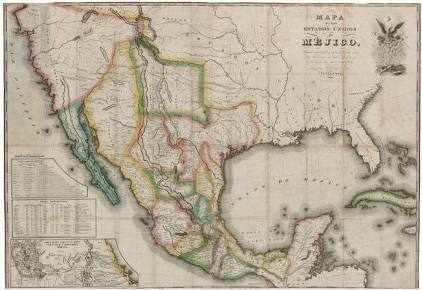
Mapa de los Estados Unidos de Méjico…, 1828
Coahuila y Tejas: A Meeting Place

After 1821, an independent Mexico sought to reclaim its northern frontier through the formation of new centers of population. Under the newly-established state of Coahuila y Tejas, empresarios (land agents) such as Stephen F. Austin introduced citizens from the United States, Mexico, and Europe into their colonies.[1] The influx of new Anglo families forever changed the cultural landscape of Texas and made it a place for cultural encounters, collaborations, and eventually conflicts.[2]

This map, Map of the United States of Mexico… published by the New York firm of White, Gallaher, & White is commonly thought to be a plagiarized copy of H. S. Tanner’s copyrighted 1826 Map of The United States of Mexico, including errors made by Tanner in his original.[3]
Translated and published in Spanish, this sheet has a unique cartouche — the symbol of Mexico, an eagle with a snake in its mouth, perched atop a large cactus. Above the bird’s head is the Phrygian cap, or Liberty Cap, a symbol of freedom especially in the Age of Atlantic Revolutions, which includes both the American and Mexican independence movements.[4] The eagle clutches a ribbon proclaiming the Federal Republic of Mexico and each paddle of the cactus bears the name of a Mexican state. The state of Coahuila y Tejas is at the top center of the cactus.[5]

Texas is labeled “Tejas” on the map and features the towns of San Antonio de Bejar, Matagorda, Nacogdoches, the missions of San Saba and La Bahia, various forts, including El Paso, and Indian settlements indicated by tipis. The Neches, Colorado, Trinity, Guadalupe, San Marcos, Brazos, Nueces, and Rio del Norte (the Rio Grande) Rivers, and other smaller streams are all labeled on the map.

Three charts are included, which provide information on the distances between important locations in Mexico, statistical data on major Mexican towns and cities, and an inset map detailing the major roads approaching Mexico City from Veracruz on the Gulf of Mexico.
White, Gallaher, and White’s map was reissued sixteen years later, in 1844, to coincide with the growing interest in Texas annexation. To capitalize on this interest in the Republic of Texas and the nation of Mexico, New York publisher John Disturnell bought the copper plates for this map and began reissuing it in his own name in 1845, without making any corrections to errors from Tanner’s original, or updating it to include items “discovered” in the 20-plus years since its first-run printing by Tanner.[6]

This map serves not only as an example of the diplomatic uses of cartography but of the rampant plagiarism occurring in the cartographic world of the nineteenth century.


This map is part of the Holcomb Digital Map Collection, a diverse group of items consisting of over 100 maps, atlases, books, and pamphlets belonging to Frank and Carol Holcomb of Houston. This map appears in the GLO database as a result of a 2014 collaboration between the Holcombs and the GLO Archives to preserve and make these important maps available to the public.
[1] For more on the formation of Coahuila y Texas see Handbook of Texas Online, S. S. McKay, “Constitution of Coahuila and Texas,” accessed April 11, 2017, http://www.tshaonline.org/handbook/online/articles/ngc01 and Handbook of Texas Online, “Coahuila and Texas,” accessed April 11, 2017, http://www.tshaonline.org/handbook/online/articles/usc01.
[2] For more on the original Anglo settlers of Texas see Handbook of Texas Online, Christopher Long, “Old Three Hundred,” accessed April 11, 2017, http://www.tshaonline.org/handbook/online/articles/umo01.
[3] For a look at Tanner’s 1826 map see: https://www.historictexasmaps.com/collection/search-results/93939-a-map-of-the-united-states-of-mexico-as-organized-and-defined-by-the-several-acts-of-the-congress-of-that-republic-rees-jones-digital-map-collection
[4] For more on the Liberty cap as a symbol see https://www.britannica.com/art/Phrygian-cap; for more on its use in nineteenth-century revolutions see: Harden, J. David. “Liberty Caps and Liberty Trees.” Past & Present, no. 146 (1995): 66–102. For more on the Age of Atlantic Revolutions see https://ageofrevolutions.com/2016/05/30/atlantic-revolutions-reading-list/
[5] For more on the history of the eagle and cactus symbol of Mexico see: https://www.wdl.org/en/item/6749/
[6] To see Disturnell’s reissue of 1847, see GLO Map #93878 https://www.historictexasmaps.com/collection/search-results/93878-mapa-de-los-estados-unidos-de-mejico-segun-lo-organizado-y-definido-por-las-varias-actas-del-congreso-de-dicha-republica-y-construido-por-las-mejores-autoridades-holcomb-digital-map-collection
